Surveying is one of the most important activities in civil engineering. It helps determine the position, distance, and elevation of different points on or near the Earth’s surface. These measurements are essential for planning, designing, and constructing engineering projects such as buildings, roads, dams, and bridges.
In earlier times, surveyors used simple tools like chains, tapes, compasses, and theodolites. While these instruments worked well, they required a lot of time and manual effort. The accuracy also depended on the skill of the surveyor.
With the advancement of technology, surveying has become much faster and more precise. One of the most important modern tools used today is the Total Station. It combines the functions of a theodolite, an electronic distance measurement (EDM) device, and a computer processor. This makes it a complete surveying instrument that can measure, calculate, and store data efficiently.
What is a Total Station?
A Total Station is an electronic and optical instrument widely used in surveying and construction. It can measure both horizontal and vertical angles as well as distances from a single setup point. Using these measurements, it automatically calculates coordinates (X, Y, Z), elevations, and even areas, making it a complete tool for modern surveying.
A Total Station combines three main instruments:
🔹 Theodolite: Measures horizontal and vertical angles accurately.
🔹 EDM (Electronic Distance Measurement) device: Measures distances using reflected electromagnetic or laser waves.
🔹 Microprocessor: Processes the measurements, calculates coordinates, and stores data digitally.
Key Features and Uses of a Total Station
The Total Station offers several features that make it indispensable in civil engineering and surveying projects:
🔹 Widely used in civil engineering, construction layout, road alignment, and mapping
🔹 Known for high precision, fast operation, and reliable digital data storage
🔹 Plays a key role in large infrastructure and land development projects
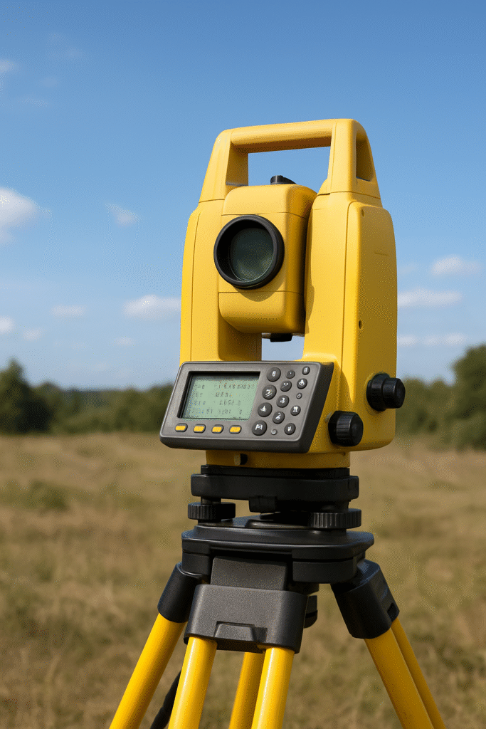
Main Components of a Total Station
A Total Station is made up of several important parts that work together to collect accurate survey data.
🔹 Telescope:
Used for sighting and focusing on the target or reflector prism precisely. It allows surveyors to view distant points clearly.
🔹 Electronic Distance Measurement (EDM) Unit:
This unit measures the distance between the Total Station and the reflector by sending electromagnetic or laser waves. The reflected signal is received and processed to determine the distance accurately.
🔹 Microprocessor and Data Processor:
The built-in microprocessor calculates angles, distances, coordinates, and elevations instantly. It also performs area and volume calculations on the field.
🔹 Display and Keyboard:
A digital screen displays readings, menus, and stored data. The keyboard allows users to input commands, codes, and job names easily.
🔹 Data Storage System:
Measured data can be stored in the instrument’s memory or transferred to a computer or USB device for further processing.
🔹 Battery and Power Supply:
Rechargeable batteries provide power for several hours of fieldwork. Some models also support external battery packs for long projects.
🔹 Tribrach and Mounting Base:
Ensures stability and accurate leveling of the instrument on a tripod.
Working Principle of Total Station
The Total Station works on the principle of measuring angles and distances electronically and then calculating coordinates using trigonometric formulas.
Here’s how it works step-by-step:
- The Total Station sends a laser or infrared beam toward a reflector prism placed at the target point.
- The beam reflects to the instrument, and the time taken for this round trip is measured.
- The EDM unit calculates the distance based on the time of flight of the beam.
- At the same time, the theodolite measures horizontal and vertical angles.
- The microprocessor then uses these values to compute the coordinates (X, Y, Z) of the target point.
This process is fast, automatic, and extremely accurate, making the Total Station one of the most efficient surveying tools available today.
How to Use a Total Station – Step by Step
Surveyors follow specific steps to ensure proper setup and accurate readings:
🔹 Step 1: Setup
Mount the Total Station on a tripod and level it accurately over a known reference point.
🔹 Step 2: Centering and Leveling
Use the built-in spirit level or electronic level to make sure the instrument is perfectly centered.
🔹 Step 3: Orientation
Turn the telescope toward the reflector prism or target point and focus it clearly.
🔹 Step 4: Measurement
Press the measurement key. The instrument automatically measures angles and distances.
🔹 Step 5: Data Storage
All readings are stored digitally inside the Total Station’s memory.
🔹 Step 6: Data Transfer
Transfer data to a computer using cable, USB, or Bluetooth for further processing, plotting, or mapping.
Advantages of Using Total Station
The Total Station offers many benefits over traditional surveying tools.
🔹 High Accuracy:
Provides highly precise measurements of both distance and angles, ensuring reliable results.
🔹 Fast and Efficient:
Reduces field time since it can perform multiple measurements in a single setup.
🔹 Automatic Calculations:
The inbuilt microprocessor calculates coordinates, elevations, and areas instantly.
🔹 Digital Data Storage:
Minimizes human error by storing data electronically instead of writing it manually.
🔹 Versatility:
Can be used for a wide range of tasks — from topographic surveys to structural monitoring.
🔹 Integration with Technology:
Modern Total Stations can connect to GPS, drones, and CAD software for advanced mapping and design applications.
🔹 User-Friendly Interface:
Most models have touchscreens and simple menus, making them easy to operate even for beginners.
Limitations of Total Station
Even though Total Stations are very advanced, they have a few drawbacks.
🔹 High Cost:
They are expensive to purchase, and their maintenance requires technical support.
🔹 Skilled Operation Needed:
Proper training is essential for setup, measurement, and data handling.
🔹 Weather Sensitivity:
Performance may reduce in extreme conditions like heavy rain, fog, or dust.
🔹 Battery Dependency:
Field operations are limited by battery life, especially in remote areas.
🔹 Line of Sight Requirement:
It needs a clear line of sight between the instrument and reflector to measure accurately.
Applications of Total Station in Civil Engineering
The Total Station is used in a wide variety of engineering and surveying applications.
🔹 Topographic Surveys:
Used to collect data about natural and man-made features to create contour maps and digital terrain models.
🔹 Construction Layout:
Helps in setting out positions of buildings, roads, bridges, and pipelines with precision.
🔹 Monitoring Structures:
Used for deformation and movement monitoring of dams, tunnels, and tall buildings over time.
🔹 Road and Railway Alignment:
Ensures proper alignment, gradient, and curvature in road and railway construction.
🔹 Mining and Excavation:
Helps calculate pit depths, excavation volumes, and slope stability in mining operations.
🔹 GIS and Mapping:
Provides accurate data for Geographic Information Systems (GIS), which are used in mapping and spatial analysis.
🔹 Archaeological and Heritage Surveys:
Records the exact position and dimensions of ancient structures or monuments for preservation and study.
Future of Total Station Technology
Modern Total Stations are now integrating GPS (Global Positioning System), Bluetooth, and Wi-Fi technologies for real-time data sharing. Some advanced models also feature robotic operation — meaning they can automatically track the prism and take measurements without manual adjustment.
The latest Reflectorless Total Stations can even measure distances without using a prism, making work faster in hard-to-reach places.
With continuous advancements, Total Stations are becoming more accurate, compact, and user-friendly — shaping the future of digital surveying.
Conclusion
The Total Station has revolutionized the field of surveying by combining accuracy, speed, and advanced technology in a single device. It simplifies complex surveying tasks, saves time, and ensures reliable data for planning and construction.
From small building layouts to massive infrastructure projects, it remains an essential tool for civil engineers, surveyors, and geospatial professionals.
As technology continues to evolve, the integration of GPS, drones, and cloud-based data management will make the Total Station even more powerful and efficient — ensuring that surveying remains a cornerstone of modern civil engineering.
Leave a Reply